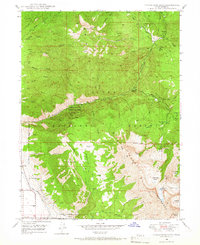
1948 Map of Timpanogos Cave
USGS Topo · Published 1966About this map
Mount Timpanogos dominates this 1948 landscape, rising above the deep canyons carved by the American Fork river. This postwar survey details the rugged alpine topography of the Uinta National Forest during a period of expanding recreational and industrial infrastructure. The map meticulously traces the subterranean features of the Timpanogos Cave National Monument, including both Timpanogos Cave and Hansen Cave, while showing the surface progress of the Salt Lake City Aqueduct and Provo Reservoir Canal to the southwest.
Find a feature on this map
55 named features on this map. Tap any name to fly to it.
Don’t see what you’re looking for? This feature index may not catch every label — zoom into the map to look around manually.
Map Details
Editions of this 1948 Timpanogos Cave Map
4 editions found
Other maps of this area

1885 · Salt Lake
USGS Topo · 1:250,000

1925 · Ft. Douglas
USGS Topo · 1:125,000

1928 · Ft. Douglas
USGS Topo · 1:125,000

1948 · Timpanogos Cave
USGS Topo · 1:24,000

1948 · Orem
USGS Topo · 1:24,000

1948 · Orem
USGS Topo · 1:62,500

1948 · Aspen Grove
USGS Topo · 1:24,000

1948 · Bridal Veil Falls
USGS Topo · 1:24,000

1950 · Orem
USGS Topo · 1:24,000

1950 · Aspen Grove
USGS Topo · 1:24,000