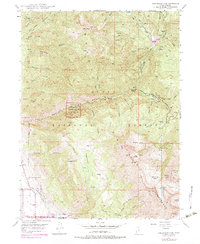
1948 Map of Timpanogos Cave
USGS Topo · Published 1978About this map
Timpanogos Cave National Monument centers this 1948 survey, showcasing the subterranean geography of Timpanogos Cave and Hansen Cave carved into the limestone of the Wasatch Range. The landscape is defined by steep glacial features, including Pika Cirque, Primrose Cirque, and the Timpanogos Basin beneath Roberts Horn. This mid-century view captures the infrastructure of the Uinta National Forest before major modern expansions, featuring the Timpooneke Guard Sta and the South Fork Ranger Sta along the American Fork river. Human impact on the high-elevation terrain is visible through the engineering of the Salt Lake City Aqueduct and several Prospects near Box Elder. Travel through the canyon follows the winding Alpine Scenic Highway, providing access to the recreational camp at Mutual Dell and the high alpine waters of Emerald Lake.
Find a feature on this map
55 named features on this map. Tap any name to fly to it.
Don’t see what you’re looking for? This feature index may not catch every label — zoom into the map to look around manually.
Map Details
Editions of this 1948 Timpanogos Cave Map
4 editions found
Other maps of this area

1885 · Salt Lake
USGS Topo · 1:250,000

1925 · Ft. Douglas
USGS Topo · 1:125,000

1928 · Ft. Douglas
USGS Topo · 1:125,000

1948 · Timpanogos Cave
USGS Topo · 1:24,000

1948 · Orem
USGS Topo · 1:24,000

1948 · Orem
USGS Topo · 1:62,500

1948 · Aspen Grove
USGS Topo · 1:24,000

1948 · Bridal Veil Falls
USGS Topo · 1:24,000

1950 · Orem
USGS Topo · 1:24,000

1950 · Aspen Grove
USGS Topo · 1:24,000