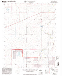
1996 Map of Timpas NE
USGS Topo · Published 2000About this map
Comanche National Grassland dominates the southern portion of this mid-1990s survey, representing a significant landscape of protected shortgrass prairie in Otero County. The terrain is defined by a network of water management features essential for ranching and agriculture in this semi-arid region, including Swink Reservoir No 1 to the northwest and Prairie Land Reservoir No 1 further south. These reservoirs, along with the meandering path of Dry Creek, indicate the vital role of water storage and drainage in shaping local land use. Industrial activity is sparsely represented by a Gravel Pit and a solitary Drill Hole, while a Flowing Well serves as a reminder of the subsurface hydrological resources tapped for regional needs. The map captures a transition between managed federal grasslands and private agricultural inholdings, punctuated by an extensive system of pipelines and levies that underscore the engineering required to sustain this environment.
Find a feature on this map
9 named features on this map. Tap any name to fly to it.
Don’t see what you’re looking for? This feature index may not catch every label — zoom into the map to look around manually.
Map Details
Editions of this 1996 Timpas NE Map
This is the sole edition of this map. No revisions or reprints were ever made.
Other maps of this area

1891 · Catlin
USGS Topo · 1:125,000

1891 · Timpas
USGS Topo · 1:125,000

1893 · Catlin
USGS Topo · 1:125,000

1894 · Timpas
USGS Topo · 1:125,000

1954 · Elder
USGS Topo · 1:24,000

1954 · Manzanola
USGS Topo · 1:24,000

1954 · Lamar
USGS Topo · 1:250,000

1955 · Rocky Ford
USGS Topo · 1:24,000

1955 · La Junta
USGS Topo · 1:250,000

1958 · La Junta
USGS Topo · 1:250,000