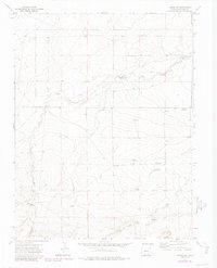
1972 Map of Timpas SW
USGS Topo · Published 1985About this map
West Dry Creek and South Dry Creek define the landscape of this Otero County region, where water management is the primary marker of human activity. The map reveals an intricate network of livestock and agricultural infrastructure, including numerous family-named landmarks like Haight Reservoir, Smith Reservoir, and Larson Reservoir. Settlement is sparse, with Dry Creek Camp being a notable focal point among the drainage systems.
Find a feature on this map
25 named features on this map. Tap any name to fly to it.
Don’t see what you’re looking for? This feature index may not catch every label — zoom into the map to look around manually.
Map Details
Editions of this 1972 Timpas SW Map
3 editions found
Other maps of this area

1891 · Timpas
USGS Topo · 1:125,000

1891 · Apishapa
USGS Topo · 1:125,000

1893 · Apishapa
USGS Topo · 1:125,000

1894 · Timpas
USGS Topo · 1:125,000

1897 · Apishapa
USGS Topo · 1:125,000

1954 · Trinidad
USGS Topo · 1:250,000

1955 · La Junta
USGS Topo · 1:250,000

1955 · Trinidad
USGS Topo · 1:250,000

1958 · La Junta
USGS Topo · 1:250,000

1958 · Trinidad
USGS Topo · 1:250,000