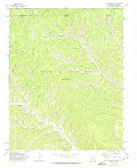
1971 Map of Tin Pan Canyon
USGS Topo · Published 1974About this map
Beaubien and Miranda Grant (Maxwell) territory defines this high-altitude landscape along the border of Colorado and New Mexico, dominated by a dense network of drainages feeding the Canadian River. This 1971 field-checked survey highlights the industrial and land-grant history of Colfax County, centered around small settlements like Brilliant and Dillon. The area is carved by a complex system of namesake features including Tin Pan Canyon, York Canyon, and Dutchman Canyon, where numerous Prospects and a Mine indicate the region's mineral interests.
Find a feature on this map
36 named features on this map. Tap any name to fly to it.
Don’t see what you’re looking for? This feature index may not catch every label — zoom into the map to look around manually.
Map Details
Editions of this 1971 Tin Pan Canyon Map
This is the sole edition of this map. No revisions or reprints were ever made.
Other maps of this area

1891 · Spanish Peaks
USGS Topo · 1:125,000

1892 · Elmoro
USGS Topo · 1:125,000

1893 · Spanish Peaks
USGS Topo · 1:125,000

1893 · Elmoro
USGS Topo · 1:125,000

1895 · Spanish Peaks
USGS Topo · 1:125,000

1897 · Elmoro
USGS Topo · 1:125,000

1897 · Spanish Peaks
USGS Topo · 1:125,000

1900 · Spanish Peaks
USGS Topo · 1:125,000

1912 · Raton
USGS Topo · 1:62,500

1914 · Raton
USGS Topo · 1:62,500