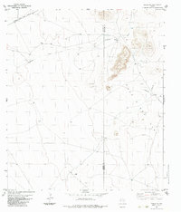
1983 Map of Tinaja NE
USGS Topo · Published 1983About this map
Loma Vista Ranch and One O One Ranch anchor this landscape along the border of Presidio and Brewster Counties in the Trans-Pecos region of West Texas. The high-desert terrain is defined by the expansive One Flat and the meandering path of Antelope Draw, which cuts through the northwestern portion of the quadrangle. Transportation and infrastructure are concentrated in the northern reaches, where the Atchison Topeka and Santa Fe railroad runs parallel to modern thoroughfares. Evidence of local activity and land use is sparse but distinct, marked by a remote Landing Strip, several cattle tanks, and a scattered Gravel Pit. The map captures a moment in the early 1980s when large-scale ranching operations and the railroad still dictated the footprint of human presence in this isolated part of the state.
Find a feature on this map
11 named features on this map. Tap any name to fly to it.
Don’t see what you’re looking for? This feature index may not catch every label — zoom into the map to look around manually.
Map Details
Editions of this 1983 Tinaja NE Map
This is the sole edition of this map. No revisions or reprints were ever made.
Other maps of this area

1895 · Alpine
USGS Topo · 1:125,000

1954 · Fort Stockton
USGS Topo · 1:250,000

1958 · Fort Stockton
USGS Topo · 1:250,000

1972 · Paisano
USGS Topo · 1:24,000

1972 · Nopal
USGS Topo · 1:24,000

1972 · Alpine South
USGS Topo · 1:24,000

1973 · Fort Stockton
USGS Topo · 1:250,000
1983 · Cactus Flat
USGS Topo · 1:24,000
1983 · Goat Mountain
USGS Topo · 1:24,000
1983 · Tinaja
USGS Topo · 1:24,000