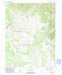
1992 Map of Tintic Junction
USGS Topo · Published 1992About this map
Mining operations and early industrial infrastructure dominate the eastern slopes of the Tintic Mountains in this 1992 revision. The landscape is a detailed record of the Tintic Mining District's footprint, showcasing a dense network of extraction sites like the Victoria Gold Mine, Yankee Girl Mine, and Evans Mine. While much of the active extraction had subsided by the late 20th century, the physical remnants define the area, including the Old Railroad Grade and an abandoned grain elevator at Knight. Settlements like Mammoth and Silver City remain anchored to the gulches and flats that once supported a thriving ore economy. The presence of three distinct burial grounds—Eureka Cem, Fitch Cem, and Silver City Cem—offers significant value for genealogists tracing the families that populated these mining camps. From the high points of Hannifin Peak to the broad expanse of Tintic Valley, the map captures a transition from industrial intensity to a quieter rural character.
Find a feature on this map
63 named features on this map. Tap any name to fly to it.
Don’t see what you’re looking for? This feature index may not catch every label — zoom into the map to look around manually.
Map Details
Editions of this 1992 Tintic Junction Map
This is the sole edition of this map. No revisions or reprints were ever made.
Other maps of this area

1885 · Sevier Desert
USGS Topo · 1:250,000

1885 · Tooele Valley
USGS Topo · 1:250,000

1947 · Fivemile Pass
USGS Topo · 1:62,500

1947 · Allens Ranch
USGS Topo · 1:24,000

1947 · Boulter Peak
USGS Topo · 1:24,000

1949 · Eureka
USGS Topo · 1:24,000

1949 · Allens Ranch
USGS Topo · 1:24,000

1953 · Tooele
USGS Topo · 1:250,000

1953 · Delta
USGS Topo · 1:250,000

1954 · Mc Intyre
USGS Topo · 1:24,000