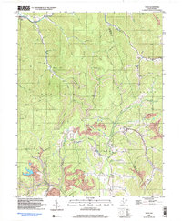
1997 Map of Tioga
USGS Topo · Published 2003About this map
The Birch River flows through the northern reaches of this Nicholas County territory, marking a landscape defined by its deep drainages and industrial activity in the late 1990s. The settlement of Tioga serves as a focal point near the center of the map, situated amidst a complex network of waterways like Beaver Run and Walnut Fork. This era shows a clear intersection of rural community life and resource extraction, with scattered mines and a prominent Tailings Pond located south of the main town site.
Find a feature on this map
70 named features on this map. Tap any name to fly to it.
Don’t see what you’re looking for? This feature index may not catch every label — zoom into the map to look around manually.
Map Details
Editions of this 1997 Tioga Map
This is the sole edition of this map. No revisions or reprints were ever made.
Other maps of this area

1889 · Nicholas
USGS Topo · 1:125,000

1891 · Nicholas
USGS Topo · 1:125,000

1893 · Sutton
USGS Topo · 1:125,000

1901 · Nicholas
USGS Topo · 1:125,000

1908 · Gassaway
USGS Topo · 1:48,000

1908 · Sutton
USGS Topo · 1:48,000

1910 · Sutton Special
USGS Topo · 1:62,500

1910 · Gassaway
USGS Topo · 1:62,500

1913 · Summersville
USGS Topo · 1:48,000

1915 · Cowen
USGS Topo · 1:48,000