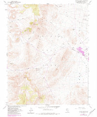
1960 Map of Tippipah Spring
USGS Topo · Published 1984About this map
The Nevada Test Site defines the geography of this high-desert region, where the Eleana Range and Shoshone Mountain meet the western edge of Yucca Flat. In a landscape marked by strategic utility, infrastructure like the Tippipah Underground Road and an Observation Station are situated among landforms like Big Butte and the Sugar Loaves. Natural water sources, critical in this arid basin, are represented by Tippipah Spring and a nearby Water Tunnel. The map delineates specific zones including Area 1, Area 2, and Area 4, indicating the specialized division of the territory during this period of atomic research. Industrial activity is visible through Trenches, Prospects, and a Gravel Pit located along the flats, while the geological structure is punctuated by Syncline Ridge and the winding Redrock Valley.
Find a feature on this map
30 named features on this map. Tap any name to fly to it.
Don’t see what you’re looking for? This feature index may not catch every label — zoom into the map to look around manually.
Map Details
Editions of this 1960 Tippipah Spring Map
3 editions found
Other maps of this area

1908 · Kawich
USGS Topo · 1:250,000

1908 · Furnace Creek
USGS Topo · 1:250,000

1910 · Furnace Creek
USGS Topo · 1:250,000

1942 · Wheelbarrow Peak
USGS Topo · 1:125,000

1942 · Skull Mountain
USGS Topo · 1:125,000

1948 · Death Valley
USGS Topo · 1:250,000

1952 · Topopah Spring
USGS Topo · 1:62,500

1952 · Tippipah Spring
USGS Topo · 1:62,500

1952 · Timber Mountain
USGS Topo · 1:62,500
1952 · Cane Spring
USGS Topo · 1:62,500