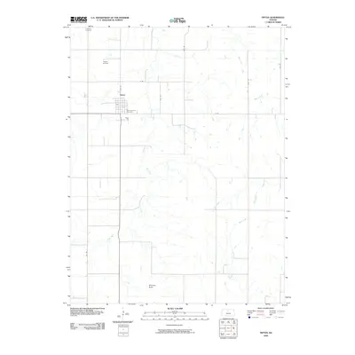
2009 Map of Tipton
USGS Topo · Published 2009About this map
Tipton serves as the central hub of this agricultural landscape in Mitchell County, characterized by a dense network of sectional roads and meandering prairie waterways. The town's local heritage is anchored by religious and community landmarks, including the Saint Boniface Cemetery on the southern edge of the settlement and the Lutheran Cemetery further north. The surrounding terrain is defined by the branching tributaries of Carr Creek, which winds through the center of the sheet, while other drainage systems like Mill Creek and Walnut Creek shape the eastern reaches. A notable high point in the south, Williams Butte, provides a distinctive break in the otherwise steady transition of the plains. This 2009 survey also documents the local infrastructure of the era, from the Tipton Airfield northwest of town to the established local routes such as 110th Rd and 1st Ave.
Find a feature on this map
18 named features on this map. Tap any name to fly to it.
Don’t see what you’re looking for? This feature index may not catch every label — zoom into the map to look around manually.
Map Details
Editions of this 2009 Tipton Map
This is the sole edition of this map. No revisions or reprints were ever made.
Other maps of this area

1894 · Beloit
USGS Topo · 1:125,000

1896 · Osborne
USGS Topo · 1:125,000

1953 · Downs South
USGS Topo · 1:24,000

1953 · Waconda Springs
USGS Topo · 1:24,000

1953 · Glen Elder South
USGS Topo · 1:24,000

1955 · Beloit
USGS Topo · 1:250,000

1959 · Beloit
USGS Topo · 1:250,000

1967 · Hunter
USGS Topo · 1:24,000
1968 · Ash Grove
USGS Topo · 1:24,000
1978 · Tipton
USGS Topo · 1:24,000