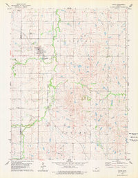
1978 Map of Tipton
USGS Topo · Published 1979About this map
Tipton serves as the central hub of this northern Kansas landscape, situated along the Atchison Topeka and Santa Fe railroad line. The settlement pattern is defined by its agricultural foundations, with the town center featuring localized infrastructure like the Tipton Airfield and dedicated Sewage Disposal Ponds. The surrounding countryside is divided into named townships including Pittsburg, Bloom, and Custer, which are deeply marked by their spiritual and communal history. Genealogy researchers will find significant value in the documentation of several burial grounds, including St Boniface Cem just south of town, Lutheran Cem to the northwest, and the more isolated Union Cem. The terrain is characterized by the winding paths of Carr Creek and Mill Creek, which cut through the high plains toward the Blue Hills region.
Find a feature on this map
22 named features on this map. Tap any name to fly to it.
Don’t see what you’re looking for? This feature index may not catch every label — zoom into the map to look around manually.
Map Details
Editions of this 1978 Tipton Map
This is the sole edition of this map. No revisions or reprints were ever made.
Other maps of this area

1894 · Beloit
USGS Topo · 1:125,000

1896 · Osborne
USGS Topo · 1:125,000

1953 · Downs South
USGS Topo · 1:24,000

1953 · Waconda Springs
USGS Topo · 1:24,000

1953 · Glen Elder South
USGS Topo · 1:24,000

1955 · Beloit
USGS Topo · 1:250,000

1959 · Beloit
USGS Topo · 1:250,000

1967 · Hunter
USGS Topo · 1:24,000
1968 · Ash Grove
USGS Topo · 1:24,000
1978 · Blue Hill
USGS Topo · 1:24,000