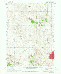
1965 Map of Tipton West
USGS Topo · Published 1967About this map
Tipton serves as the primary hub in this mid-1960s Iowa landscape, characterized by the steady grid of rural sections and the winding course of Rock Creek. The western edge of the city shows significant civic infrastructure, including the Fairground and local Sewage Disposal works. Further west, the hamlet of Buchanan sits along an Old Railroad Grade, providing a clear trace of the area's shifting transportation priorities as rail lines were decommissioned.
Find a feature on this map
25 named features on this map. Tap any name to fly to it.
Don’t see what you’re looking for? This feature index may not catch every label — zoom into the map to look around manually.
Map Details
Editions of this 1965 Tipton West Map
This is the sole edition of this map. No revisions or reprints were ever made.
Other maps of this area

1889 · Tipton
USGS Topo · 1:62,500

1890 · Tipton
USGS Topo · 1:62,500

1891 · Mechanicsville
USGS Topo · 1:62,500

1891 · Wilton Junction
USGS Topo · 1:62,500

1894 · Mechanicsville
USGS Topo · 1:62,500

1894 · West Liberty
USGS Topo · 1:62,500

1901 · Stanwood
USGS Topo · 1:125,000
1953 · Tipton East
USGS Topo · 1:24,000
1953 · Lime City
USGS Topo · 1:24,000

1958 · Davenport
USGS Topo · 1:250,000