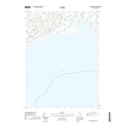
2021 Map of Tisbury Great Pond
USGS Topo · Published 2021About this map
Chilmark and the surrounding south shore of Martha's Vineyard are defined by the meeting of complex freshwater systems and the Atlantic Ocean. The landscape is etched with historical land divisions and glacial features, notably seen in the long fingers of water stretching inland like Quenames Cove and the expansive Tisbury Great Pond. The area maintains a rural character with narrow roads like Marion's Way and Tabor House Rd winding through the interior hills. Along the coast, Chilmark Pond is separated from the sea by a narrow barrier beach, while the inland terrain is carved by watercourses such as Fulling Mill Brook and the Tiasquam River. Genealogy and local history are anchored at the Chilmark Cem, located near the center of the settlement. The map also captures the distinct coastal topography of areas like Waldron Bottom and Willow Tree Bottom, reflecting the island's unique agricultural and maritime heritage.
Find a feature on this map
63 named features on this map. Tap any name to fly to it.
Don’t see what you’re looking for? This feature index may not catch every label — zoom into the map to look around manually.
Map Details
Editions of this 2021 Tisbury Great Pond Map
This is the sole edition of this map. No revisions or reprints were ever made.
Other maps of this area

1887 · Gay Head
USGS Topo · 1:62,500

1887 · Marthas Vineyard
USGS Topo · 1:62,500

1889 · Gay Head
USGS Topo · 1:62,500

1889 · Marthas Vineyard
USGS Topo · 1:62,500

1893 · Gay Head
USGS Topo · 1:62,500

1894 · Marthas Vineyard
USGS Topo · 1:62,500

1942 · Marthas Vineyard
USGS Topo · 1:125,000

1944 · Tisbury Great Pond
USGS Topo · 1:31,680

1944 · Vineyard Haven
USGS Topo · 1:31,680
1944 · Naushon Island
USGS Topo · 1:31,680