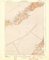
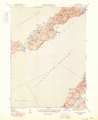
1944 Map of Naushon Island
USGS Topo · Published 1944About this map
Elizabeth Islands and the northern shoreline of Marthas Vineyard define this maritime survey conducted in the early 1940s. The map captures the isolated character of Naushon Island, where the Tarpaulin Cove Lighthouse stands as a primary navigational marker for vessels navigating between Buzzards Bay and Vineyard Sound. This area remains largely dominated by its natural features, from the dense Ramshead Woods and Black Woods to the numerous coastal depressions like Eagle Hollow. Coastal features like Robinsons Hole illustrate the narrow tidal passages between the islands. On the southern shore, the township of Chilmark and the heights of Gay Head appear, showing the early road network and scattered ponds including Hartock Pond and Grey Pond along the Vineyard's edge.
Find a feature on this map
30 named features on this map. Tap any name to fly to it.
Don’t see what you’re looking for? This feature index may not catch every label — zoom into the map to look around manually.
Map Details
Editions of this 1944 Naushon Island Map
5 editions found
Other maps of this area

1885 · New Bedford
USGS Topo · 1:62,500

1886 · Falmouth
USGS Topo · 1:62,500

1887 · Gay Head
USGS Topo · 1:62,500

1888 · New Bedford
USGS Topo · 1:62,500

1888 · Falmouth
USGS Topo · 1:62,500

1889 · Gay Head
USGS Topo · 1:62,500

1893 · Gay Head
USGS Topo · 1:62,500

1893 · Falmouth
USGS Topo · 1:62,500

1893 · New Bedford
USGS Topo · 1:62,500

1915 · Falmouth
USGS Topo · 1:62,500