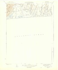
1944 Map of Tisbury Great Pond
USGS Topo · Published 1944About this map
The south shore of Marthas Vineyard in the mid-1940s is defined by a rhythmic sequence of coastal ponds and finger-like coves. The boundary between the towns of Chilmark, West Tisbury, and Edgartown is traced across a landscape dominated by water and low-lying peninsulas. Tisbury Great Pond sits at the center of this network, fed by numerous branches including Tississa and Deep Bottom Cove. This survey, produced by the Department of Public Works and J.W.V. Somers, captures the area's rural character before extensive modern development.
Find a feature on this map
38 named features on this map. Tap any name to fly to it.
Don’t see what you’re looking for? This feature index may not catch every label — zoom into the map to look around manually.
Map Details
Editions of this 1944 Tisbury Great Pond Map
3 editions found
Other maps of this area

1887 · Gay Head
USGS Topo · 1:62,500

1887 · Marthas Vineyard
USGS Topo · 1:62,500

1889 · Gay Head
USGS Topo · 1:62,500

1889 · Marthas Vineyard
USGS Topo · 1:62,500

1893 · Gay Head
USGS Topo · 1:62,500

1894 · Marthas Vineyard
USGS Topo · 1:62,500

1942 · Marthas Vineyard
USGS Topo · 1:125,000

1944 · Tisbury Great Pond
USGS Topo · 1:31,680

1944 · Vineyard Haven
USGS Topo · 1:31,680
1944 · Edgartown
USGS Topo · 1:31,680