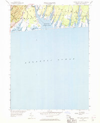
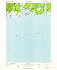
1951 Map of Tisbury Great Pond
USGS Topo · Published 1970About this map
The south shore of Martha’s Vineyard is defined here by the intricate coastline of Tisbury Great Pond and a series of coastal salt ponds separated from the Atlantic Ocean by a narrow barrier beach. This 1951 revision captures the area’s rural, coastal character, showing small settlements like Quansoo and Tississa connected by a network of dirt tracks and historic routes such as the Kings Highway. The landscape is dominated by long, finger-like coves such as Deep Bottom Cove and Thumb Cove that reach inland toward West Tisbury. To the west, the terrain rises toward Ridge Hill, while the eastern portion near Edgartown features larger water bodies like Oyster Pond and Watcha Pond. This map details the mid-century shoreline before significant modern development, preserving the locations of family-named landmarks like Nabs Corner and the agricultural roads that serviced this maritime environment.
Find a feature on this map
39 named features on this map. Tap any name to fly to it.
Don’t see what you’re looking for? This feature index may not catch every label — zoom into the map to look around manually.
Map Details
Editions of this 1951 Tisbury Great Pond Map
5 editions found
Other maps of this area

1887 · Gay Head
USGS Topo · 1:62,500

1887 · Marthas Vineyard
USGS Topo · 1:62,500

1889 · Gay Head
USGS Topo · 1:62,500

1889 · Marthas Vineyard
USGS Topo · 1:62,500

1893 · Gay Head
USGS Topo · 1:62,500

1894 · Marthas Vineyard
USGS Topo · 1:62,500

1942 · Marthas Vineyard
USGS Topo · 1:125,000

1944 · Tisbury Great Pond
USGS Topo · 1:31,680

1944 · Vineyard Haven
USGS Topo · 1:31,680
1944 · Edgartown
USGS Topo · 1:31,680