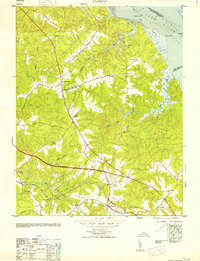
1953 Map of Toano
USGS Topo · Published 1953About this map
The Chesapeake and Ohio railroad corridor anchors this mid-century portrait of the Virginia Peninsula, following the ridgeline through Toano and passing Branch Siding. The landscape is defined by the transition from the tidewater flats of the York River to a series of wooded drainages including Bird Swamp, Wahrani Swamp, and Richardson Swamp. This 1953 reprint of an earlier military edition reflects the rural character of the region shortly after World War II, showing a network of small settlements like Barhamsville and Holly Forks connected by established routes like the Pocahontas Trail. Local history is preserved through the mapping of numerous community landmarks, most notably the Hickory Neck Church and St Johns Church, alongside family-named markers such as Bock Cem. The map provides a detailed view of the infrastructure of James City and New Kent counties before modern interstate development altered the traditional road patterns.
Find a feature on this map
36 named features on this map. Tap any name to fly to it.
Don’t see what you’re looking for? This feature index may not catch every label — zoom into the map to look around manually.
Map Details
Editions of this 1953 Toano Map
This is the sole edition of this map. No revisions or reprints were ever made.
Other maps of this area

1906 · Williamsburg
USGS Topo · 1:62,500

1917 · Urbanna
USGS Topo · 1:62,500

1917 · Toano
USGS Topo · 1:62,500

1918 · Toano
USGS Topo · 1:62,500

1919 · New Kent
USGS Topo · 1:62,500

1943 · Richmond
USGS Topo · 1:250,000

1949 · Shacklefords
USGS Topo · 1:24,000

1949 · New Kent
USGS Topo · 1:24,000

1949 · Richmond
USGS Topo · 1:250,000

1950 · West Point
USGS Topo · 1:24,000