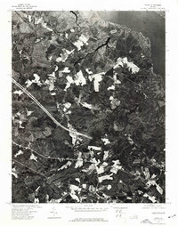
1973 Map of Toano
USGS Topo · Published 1977About this map
The York River borders the northeastern edge of this orthophotoquad, which emphasizes the rural and agricultural character of James City County during the early 1970s. Produced by the U.S. Geological Survey in cooperation with the Virginia Division of Mineral Resources, the imagery captures a patchwork of cleared farmland and dense woodlands. The visible landscape is dominated by the intersection of major transportation corridors and scattered farmsteads, revealing the transition from traditional agrarian land use to modern infrastructure. Unlike traditional line-drawn maps, this aerial perspective provides a literal view of the vegetation and land-clearing patterns along the coastal plain as they existed in April 1973.
Find a feature on this map
1 named feature on this map. Tap any name to fly to it.
Don’t see what you’re looking for? This feature index may not catch every label — zoom into the map to look around manually.
Map Details
Editions of this 1973 Toano Map
This is the sole edition of this map. No revisions or reprints were ever made.
Other maps of this area

1906 · Williamsburg
USGS Topo · 1:62,500

1917 · Urbanna
USGS Topo · 1:62,500

1917 · Toano
USGS Topo · 1:62,500

1918 · Toano
USGS Topo · 1:62,500

1919 · New Kent
USGS Topo · 1:62,500

1943 · Richmond
USGS Topo · 1:250,000

1949 · Shacklefords
USGS Topo · 1:24,000

1949 · New Kent
USGS Topo · 1:24,000

1949 · Richmond
USGS Topo · 1:250,000

1950 · West Point
USGS Topo · 1:24,000