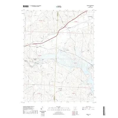
2019 Map of Toboso
USGS Topo · Published 2019About this map
Licking Gorge and the striking Black Hand Rock formation define the central corridor of this Licking and Muskingum County borderland. The Licking River flows through the center of the sheet, feeding into the northern reaches of Dillon Lake near Irville. This area is characterized by several small, established rural settlements such as Toboso, Black Run, and Nashport, many of which grew alongside the river and railroad routes that historically navigated this uneven terrain. Genealogists can find several small burial grounds across the townships, including the Perry Cem and the Pleasant Valley Baptist Cem. To the north, Frazeysburg sits at the edge of the rolling landscape where Wakatomika Creek crosses the map. The collection of local cemeteries and named landmarks like Bald Knob provide a detailed perspective on the region's 21st-century rural character and long-standing community boundaries.
Find a feature on this map
103 named features on this map. Tap any name to fly to it.
Don’t see what you’re looking for? This feature index may not catch every label — zoom into the map to look around manually.
Map Details
Editions of this 2019 Toboso Map
This is the sole edition of this map. No revisions or reprints were ever made.
Other maps of this area

1909 · Newark
USGS Topo · 1:62,500

1909 · Thornville
USGS Topo · 1:62,500

1910 · Frazeysburg
USGS Topo · 1:62,500

1910 · Zanesville
USGS Topo · 1:62,500

1947 · Columbus
USGS Topo · 1:250,000

1950 · Marion
USGS Topo · 1:250,000

1961 · Columbus
USGS Topo · 1:250,000

1961 · Hanover
USGS Topo · 1:24,000

1961 · Zanesville West
USGS Topo · 1:24,000
1961 · Glenford
USGS Topo · 1:24,000