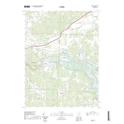
2023 Map of Toboso
USGS Topo · Published 2023About this map
The Licking River carves a deep valley through this portion of Muskingum County, creating the distinctive geological features of Licking Gorge and the notable Black Hand Rock. The landscape is defined by the transition between the rolling hills of Bald Knob and the significant water resources of Dillon Lake to the southeast. Settlements like Toboso, Nashport, and Black Run are scattered throughout the quadrangle, connected by a network of rural routes such as Blackrun Rd and Marne Rd. Genealogists will find a high density of rural burial grounds, including the Old Stone Church of Christ Cem, Shadley Cem, and Beulah Baptist Cem. This 2023 survey documents a region where the natural corridor of the river has dictated the placement of small communities and recreational areas like Rock Haven Park.
Find a feature on this map
109 named features on this map. Tap any name to fly to it.
Don’t see what you’re looking for? This feature index may not catch every label — zoom into the map to look around manually.
Map Details
Editions of this 2023 Toboso Map
This is the sole edition of this map. No revisions or reprints were ever made.
Other maps of this area

1909 · Newark
USGS Topo · 1:62,500

1909 · Thornville
USGS Topo · 1:62,500

1910 · Frazeysburg
USGS Topo · 1:62,500

1910 · Zanesville
USGS Topo · 1:62,500

1947 · Columbus
USGS Topo · 1:250,000

1950 · Marion
USGS Topo · 1:250,000

1961 · Columbus
USGS Topo · 1:250,000

1961 · Hanover
USGS Topo · 1:24,000

1961 · Zanesville West
USGS Topo · 1:24,000
1961 · Glenford
USGS Topo · 1:24,000