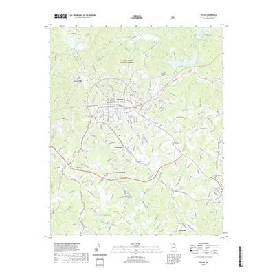
2020 Map of Toccoa
USGS Topo · Published 2020About this map
Toccoa serves as the heart of this North Georgia landscape, established at the foot of Toccoa Mtn where the Stephens County Courthouse anchors the local government. The town's development is closely tied to its natural surroundings and educational institutions, most notably Toccoa Falls College located near the landmark Toccoa Falls. The area's settlement history is preserved through numerous family and community burial grounds, including Toccoa Cem, Zebulon Cem, and Taylor Cem, which dot the terrain between Fowlertown and Carnes Creek. To the east and south, the map details the rural character of communities like Eastanollee and Union Hill, defined by the drainage of Eastanollee Cr and the N Fork Broad River. The influence of the Chattahoochee National Forest is evident in the wooded northern reaches, while industry and aviation are represented by Rock Quarry Mtn and the Toccoa RG Letourneau Field.
Find a feature on this map
222 named features on this map. Tap any name to fly to it.
Don’t see what you’re looking for? This feature index may not catch every label — zoom into the map to look around manually.
Map Details
Editions of this 2020 Toccoa Map
This is the sole edition of this map. No revisions or reprints were ever made.
Other maps of this area

1886 · Walhalla
USGS Topo · 1:125,000

1891 · Carnesville
USGS Topo · 1:125,000

1892 · Walhalla
USGS Topo · 1:125,000

1896 · Walhalla
USGS Topo · 1:125,000

1953 · Tallulah Falls
USGS Topo · 1:24,000

1954 · Greenville
USGS Topo · 1:250,000

1957 · Tugaloo Lake
USGS Topo · 1:24,000

1958 · Greenville
USGS Topo · 1:250,000

1960 · Martin
USGS Topo · 1:24,000
1963 · Holly Springs
USGS Topo · 1:24,000