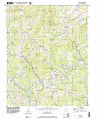
1998 Map of Todd
USGS Topo · Published 1999About this map
The South Fork New River meanders through the heart of this terrain, defining the local geography as it winds past the historic community of Todd. This late-twentieth-century landscape is characterized by a dense network of mountain ridges and knobs, including Bald Mtn, Rich Mtn, and Mulatto Mtn. The river valley serves as the primary corridor for settlement and transportation, evidenced by the path of Railroad Grade Road and the grouping of civic structures like Elkland Sch and several local congregations such as Blackburn Chapel and Bethany Ch.
Find a feature on this map
46 named features on this map. Tap any name to fly to it.
Don’t see what you’re looking for? This feature index may not catch every label — zoom into the map to look around manually.
Map Details
Editions of this 1998 Todd Map
This is the sole edition of this map. No revisions or reprints were ever made.
Other maps of this area

1889 · Wilkesboro
USGS Topo · 1:125,000

1891 · Wilkesboro
USGS Topo · 1:125,000

1893 · Cranberry
USGS Topo · 1:125,000

1895 · Cranberry
USGS Topo · 1:125,000

1899 · Cranberry
USGS Topo · 1:125,000

1902 · Cranberry
USGS Topo · 1:125,000

1934 · Boone
USGS Topo · 1:24,000

1935 · Baldwin Gap
USGS Topo · 1:24,000

1935 · Zionville
USGS Topo · 1:24,000

1936 · Blowing Rock
USGS Topo · 1:48,000