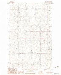
1983 Map of Todd Lakes SE
USGS Topo · Published 1983About this map
The complex drainage system of the Fort Peck Indian Reservation landscape is defined by the convergence of several major waterways, most notably Wolf Creek. This 1983 provisional survey highlights a remote section of northeastern Montana where the Valley Co Roosevelt Co boundary line bisects the territory. The map illustrates a high-desert environment characterized by the branching of the Middle Fork, East Fork, and West Fork, revealing the intricate erosion patterns and seasonal watercourses of the region. The inclusion of Dry Fork further emphasizes the arid nature of this landscape before more modern developments or modifications. This particular edition serves as a snapshot of the terrain as it was field-checked in the late 1970s, preserving the exact hydrological network used by local ranchers and residents of the era.
Find a feature on this map
6 named features on this map. Tap any name to fly to it.
Don’t see what you’re looking for? This feature index may not catch every label — zoom into the map to look around manually.
Map Details
Editions of this 1983 Todd Lakes SE Map
This is the sole edition of this map. No revisions or reprints were ever made.
Other maps of this area

1910 · Todd Lakes
USGS Topo · 1:62,500

1915 · Tule Valley
USGS Topo · 1:62,500

1915 · Oswego
USGS Topo · 1:62,500

1915 · Todd Lakes
USGS Topo · 1:62,500

1916 · Wolf Point
USGS Topo · 1:62,500

1954 · Wolf Point
USGS Topo · 1:250,000

1958 · Wolf Point
USGS Topo · 1:250,000

1972 · Flynn Creek North
USGS Topo · 1:24,000
1972 · Oswego NW
USGS Topo · 1:24,000
1972 · Wolf Point NW
USGS Topo · 1:24,000