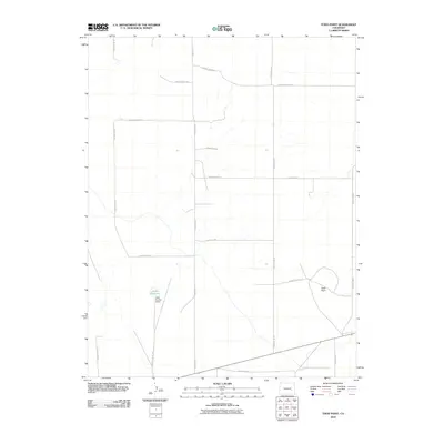
2010 Map of Todd Point
USGS Topo · Published 2010About this map
Lolita Reservoir and the engineered Lolita Number 3 Dam provide a focal point in this high plains landscape of Otero County. The terrain is characterized by a sparse network of section-line roads, such as County Road J and County Road M, which segment the arid expanse into vast agricultural or grazing blocks. In the eastern portion of the survey, the geographic rise of Todd Point stands as a primary landmark against the relatively level surroundings. This 2010 survey reveals a landscape of water management and rural transit, where boundaries like County Line 29 and County Rd 27 organize the territory between small-scale ranching or irrigation infrastructure.
Find a feature on this map
19 named features on this map. Tap any name to fly to it.
Don’t see what you’re looking for? This feature index may not catch every label — zoom into the map to look around manually.
Map Details
Editions of this 2010 Todd Point Map
This is the sole edition of this map. No revisions or reprints were ever made.
Other maps of this area

1891 · Catlin
USGS Topo · 1:125,000

1891 · Las Animas
USGS Topo · 1:125,000

1893 · Las Animas
USGS Topo · 1:125,000

1893 · Catlin
USGS Topo · 1:125,000

1954 · Meredith Hill
USGS Topo · 1:24,000

1954 · Sugar City
USGS Topo · 1:24,000

1954 · Lamar
USGS Topo · 1:250,000
1955 · Lewis Ranch
USGS Topo · 1:24,000

1958 · Lamar
USGS Topo · 1:250,000
1977 · The Pinnacles
USGS Topo · 1:24,000