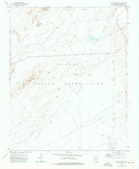
1972 Map of Toh De Niihe
USGS Topo · Published 1976About this map
Ventana Mesa and the Red Rock Rim dominate this high-desert landscape within the Navajo Indian Reservation as it was surveyed in the early 1970s. The topography is defined by complex drainage systems, including Cottonwood Wash and Tse Ba Ni Zi Ni Wash, which carve through the arid terrain. The settlement of Bekihatso sits in the southern portion of the quadrangle, connected to the wider region by a network of unimproved roads and light-duty trails that navigate around landmarks like White Horse Butte and Tse Lichii Dah Azka. A notable water feature, Toh De Niihe, provides a point of focus in the northeastern corner. This map documents a period of remote land use where traditional navigation and natural landmarks remained primary to the local geography.
Find a feature on this map
11 named features on this map. Tap any name to fly to it.
Don’t see what you’re looking for? This feature index may not catch every label — zoom into the map to look around manually.
Map Details
Editions of this 1972 Toh De Niihe Map
This is the sole edition of this map. No revisions or reprints were ever made.
Other maps of this area

1886 · Fort Defiance
USGS Topo · 1:250,000

1892 · Fort Defiance
USGS Topo · 1:250,000

1892 · Canyon De Chelly
USGS Topo · 1:250,000

1954 · Shiprock
USGS Topo · 1:250,000

1954 · Gallup
USGS Topo · 1:250,000

1955 · Chinle 4 NE
USGS Topo · 1:24,000

1955 · Chinle 4 SE
USGS Topo · 1:24,000
1955 · Ganado 1 NE
USGS Topo · 1:24,000

1958 · Gallup
USGS Topo · 1:250,000

1958 · Shiprock
USGS Topo · 1:250,000