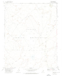
1972 Map of Tolani
USGS Topo · Published 1975About this map
The Navajo Indian Reservation landscape is defined by an intricate network of ephemeral watercourses and grazing infrastructure in this 1970s topographic study. The settlement of Tolani sits near the convergence of several major drainages, including the sprawling Balakai Wash and Pine Springs Wash. This area of Apache County shows the intersection of modern reservation life with historical landmarks, most notably the Old Indian Reservation Boundary that runs along the eastern edge of the sheet. The terrain is marked by seasonal washes such as Tse Ba Ni Zi Ni Wash and Bi-Keesh Wash, while localized features like Bekihatso, a Corral, and a Well indicate the essential role of water management and livestock in this environment. The map provides a detailed view of the unimproved roads and survey points that connected these isolated outposts before more modern development reached this part of the high desert plateau.
Find a feature on this map
11 named features on this map. Tap any name to fly to it.
Don’t see what you’re looking for? This feature index may not catch every label — zoom into the map to look around manually.
Map Details
Editions of this 1972 Tolani Map
This is the sole edition of this map. No revisions or reprints were ever made.
Other maps of this area

1886 · Fort Defiance
USGS Topo · 1:250,000

1892 · Fort Defiance
USGS Topo · 1:250,000

1892 · Canyon De Chelly
USGS Topo · 1:250,000

1954 · Shiprock
USGS Topo · 1:250,000

1954 · Gallup
USGS Topo · 1:250,000

1955 · Chinle 4 SE
USGS Topo · 1:24,000
1955 · Ganado 1 NE
USGS Topo · 1:24,000

1958 · Gallup
USGS Topo · 1:250,000

1958 · Shiprock
USGS Topo · 1:250,000

1959 · Shiprock
USGS Topo · 1:250,000