1986 Map of Tolani Lake
USGS Topo · Published 1986About this map
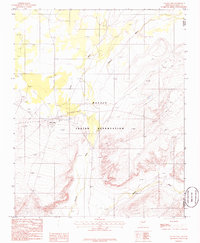
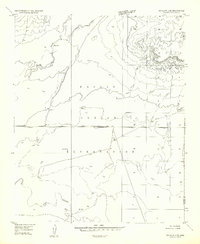
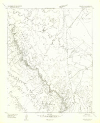
The Navajo Indian Reservation landscape is defined by the complex hydrological patterns of the Oraibi Wash and Polacca Wash in the mid-1980s. Centered on the settlement of Tolani Lake, the map illustrates a desert environment where seasonal water flow dictates the geography. The confluence of these washes near the border of Coconino Co and Navajo Co highlights the importance of natural drainage in an arid region. Grounded in 1982 field checks, the topography reveals the subtle elevation changes of the high desert, including the winding path of Jadito Wash as it moves across the reservation. Infrastructure is sparse but vital, represented by the Sewage Disposal Ponds near the main settlement, reflecting the basic utility needs of this community during this era.
Find a feature on this map
7 named features on this map. Tap any name to fly to it.
Don’t see what you’re looking for? This feature index may not catch every label — zoom into the map to look around manually.
Map Details
Editions of this 1986 Tolani Lake Map
This is the sole edition of this map. No revisions or reprints were ever made.
Other maps of this area

1883 · Tusayan
USGS Topo · 1:250,000

1886 · Tusayan
USGS Topo · 1:250,000

1947 · Flagstaff
USGS Topo · 1:250,000

1954 · Flagstaff
USGS Topo · 1:250,000
1955 · Winslow 2 SW
USGS Topo · 1:24,000
1955 · Leupp
USGS Topo · 1:62,500
1957 · Winslow 1 SW
USGS Topo · 1:24,000
1957 · Winslow 2 SE
USGS Topo · 1:24,000
1957 · Winslow 2 NW
USGS Topo · 1:24,000

1958 · Flagstaff
USGS Topo · 1:250,000