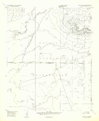
1957 Map of Winslow 2 SE
USGS Topo · Published 1957About this map
The Little Colorado River winds through the southern reaches of this landscape, anchoring a high desert environment within the Navajo Indian Reservation. This mid-century survey reveals a territory defined by careful water management, where numerous Stock Tanks, a Well, and the Windmill Reservoir indicate the essential infrastructure for ranching in an arid climate. Significant hydrological features such as Oraibi Wash and Corn Creek traverse the terrain, while man-made additions like the east-west Levee and a prominent Pipeline show the industrial hand in modifying the natural drainage and resource transport. The boundary between Coconino Co and Navajo County runs along the eastern edge, marking a jurisdictional divide in this open expanse of the Arizona plateau.
Find a feature on this map
11 named features on this map. Tap any name to fly to it.
Don’t see what you’re looking for? This feature index may not catch every label — zoom into the map to look around manually.
Map Details
Editions of this 1957 Winslow 2 SE Map
This is the sole edition of this map. No revisions or reprints were ever made.
Other maps of this area

1883 · Tusayan
USGS Topo · 1:250,000

1886 · Tusayan
USGS Topo · 1:250,000

1947 · Flagstaff
USGS Topo · 1:250,000

1954 · Winslow
USGS Topo · 1:62,500

1954 · Winslow 4 NW
USGS Topo · 1:24,000

1954 · Flagstaff
USGS Topo · 1:250,000

1955 · Winslow 2 SW
USGS Topo · 1:24,000

1955 · Leupp
USGS Topo · 1:62,500

1957 · Winslow 1 SW
USGS Topo · 1:24,000
1957 · Winslow 2 NW
USGS Topo · 1:24,000