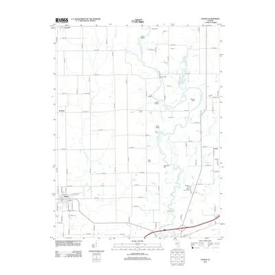
2012 Map of Toledo
USGS Topo · Published 2012About this map
Toledo serves as the focal point of this Illinois survey, located south of the meandering Embarras River. The landscape is a patchwork of rural farm roads and small settlements including Janesville, Bradbury, and Timothy. Genealogists will find a high density of rural burial grounds such as Peach Orchard Cem, Harmony Cem, and Jack Oak Cem, many of which are tucked near the hollows and bends of the local waterways. The topography is defined by the drainage systems of Cottonwood Cr and Hurricane Cr, which feed into the main river valley. Notable river crossings such as McCann Ford, Ryan Bridge, and Bowman Ford illustrate the historic transit patterns that connected these disparate farming communities before modern infrastructure dominated the region.
Find a feature on this map
85 named features on this map. Tap any name to fly to it.
Don’t see what you’re looking for? This feature index may not catch every label — zoom into the map to look around manually.
Map Details
Editions of this 2012 Toledo Map
This is the sole edition of this map. No revisions or reprints were ever made.
Other maps of this area

1933 · Toledo
USGS Topo · 1:62,500

1934 · Mattoon
USGS Topo · 1:62,500

1937 · Mattoon
USGS Topo · 1:62,500

1938 · Toledo
USGS Topo · 1:62,500

1940 · Greenup
USGS Topo · 1:62,500

1943 · Greenup
USGS Topo · 1:62,500

1953 · Teutopolis
USGS Topo · 1:62,500

1958 · Decatur
USGS Topo · 1:250,000

1961 · Decatur
USGS Topo · 1:250,000
1984 · Charleston South
USGS Topo · 1:24,000