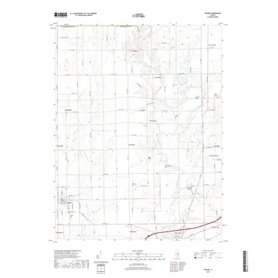
2018 Map of Toledo
USGS Topo · Published 2018About this map
Toledo and Greenup anchor this agricultural landscape in Cumberland County, situated along the winding course of the Embarras River. The terrain is characterized by a series of hollows and knolls, including Austin Hollow and Buck Knoll, which divert the local drainage of Cottonwood Creek and Hurricane Creek. The map reveals a dense network of rural life, marked by numerous family-named cemeteries such as Neal Cemetery and Hutton Cemetery, which provide significant value for genealogical research in this part of Illinois. The rural settlements of Bradbury and Timothy are linked by a grid of county roads, while landmarks like Ryan Bridge and the Sconce Bend of the river define the natural navigation of the area. This survey documents the persistent rural character of the region, where legacy orchards like Harmony Orchard Cemetery and established local crossroads continue to shape the community identity.
Find a feature on this map
59 named features on this map. Tap any name to fly to it.
Don’t see what you’re looking for? This feature index may not catch every label — zoom into the map to look around manually.
Map Details
Editions of this 2018 Toledo Map
This is the sole edition of this map. No revisions or reprints were ever made.
Other maps of this area

1933 · Toledo
USGS Topo · 1:62,500

1934 · Mattoon
USGS Topo · 1:62,500

1937 · Mattoon
USGS Topo · 1:62,500

1938 · Toledo
USGS Topo · 1:62,500

1940 · Greenup
USGS Topo · 1:62,500

1943 · Greenup
USGS Topo · 1:62,500

1953 · Teutopolis
USGS Topo · 1:62,500

1958 · Decatur
USGS Topo · 1:250,000

1961 · Decatur
USGS Topo · 1:250,000
1984 · Charleston South
USGS Topo · 1:24,000