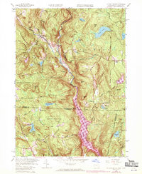
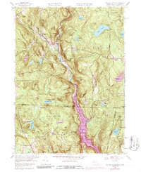
1958 Map of Tolland Center
USGS Topo · Published 1970About this map
Farmington River carves a deep valley through this borderland, where the West Branch meets the expanding waters of Colebrook River Lake. At the time of this photorevision, the landscape transition is evident as the river’s natural course gives way to the reservoir system. The small settlements of New Boston, West New Boston, and Roosterville cluster near these vital water corridors. Higher elevations are dominated by extensive public lands, including Sandisfield State Forest and Tolland State Forest, which preserve the steep, wooded terrain of Hanging Mtn and Mount Prospect. Genealogists and local historians can find traces of rural life at North Colebrook and McClaveville, alongside established community sites like Camp Jewell and several local cemeteries. The map also documents the interstate boundary between Massachusetts and Connecticut, showing how roads and topographic features like Sandy Brook traverse the state line.
Find a feature on this map
53 named features on this map. Tap any name to fly to it.
Don’t see what you’re looking for? This feature index may not catch every label — zoom into the map to look around manually.
Map Details
Editions of this 1958 Tolland Center Map
5 editions found
Other maps of this area

1887 · Granville
USGS Topo · 1:62,500

1888 · Sandisfield
USGS Topo · 1:62,500

1889 · Granville
USGS Topo · 1:62,500

1892 · Winsted
USGS Topo · 1:62,500

1892 · Granby
USGS Topo · 1:62,500

1893 · Granville
USGS Topo · 1:62,500

1893 · Sandisfield
USGS Topo · 1:62,500

1895 · Granville
USGS Topo · 1:62,500

1896 · Holyoke
USGS Topo · 1:125,000

1897 · Sandisfield
USGS Topo · 1:62,500