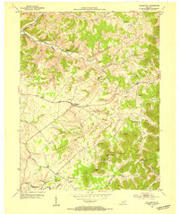
1953 Map of Tollesboro
USGS Topo · Published 1954About this map
Tollesboro sits at the center of this Kentucky landscape, where the ridge-and-hollow terrain of Lewis County meets the Licking River at the southern boundary. The 1950s geography is defined by a dense network of country churches and small rural schools, such as Pine Valley Ch, Canaan Sch, and Mt Tabor Ch, reflecting the dispersed settlement pattern of the era. The land is dominated by significant elevations like Eskalapia Mountain and Tanbark Hill, with numerous named hollows like Stouts Hollow and Happy Hollow carving through the plateau.
Find a feature on this map
47 named features on this map. Tap any name to fly to it.
Don’t see what you’re looking for? This feature index may not catch every label — zoom into the map to look around manually.
Map Details
Editions of this 1953 Tollesboro Map
2 editions found
Other maps of this area

1919 · Vanceburg
USGS Topo · 1:62,500

1929 · Springdale
USGS Topo · 1:48,000

1935 · Springdale
USGS Topo · 1:62,500

1949 · Vanceburg
USGS Topo · 1:62,500

1949 · Concord
USGS Topo · 1:24,000

1949 · Charters
USGS Topo · 1:24,000

1950 · Charters
USGS Topo · 1:24,000
1951 · Concord
USGS Topo · 1:24,000

1951 · Stricklett
USGS Topo · 1:24,000

1951 · Burtonville
USGS Topo · 1:24,000