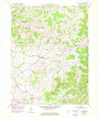
1953 Map of Tollesboro
USGS Topo · Published 1978About this map
Tollesboro serves as the central hub for this rural Lewis County landscape, situated where the uplands transition toward the North Fork Licking River. The 1950s settlement pattern is defined by a dense network of country churches and small crossroads communities, such as Ribolt, Cottageville, and Nashtown. In the southern portion of the map, the terrain rises significantly toward Eskalapia Mountain and the Kentucky Ridge, creating a series of deep hollows including Eskalapia Hollow and Runyan Hollow. Genealogy researchers will find numerous landmarks for tracing family roots, from the Salem Ch in the north to the Canaan Sch and Ruggles Camp in the south. The drainage system of Cabin Creek and its many branches, like Thoroughman Branch, dictates the placement of winding roads and farmsteads throughout the region.
Find a feature on this map
53 named features on this map. Tap any name to fly to it.
Don’t see what you’re looking for? This feature index may not catch every label — zoom into the map to look around manually.
Map Details
Editions of this 1953 Tollesboro Map
2 editions found
Other maps of this area

1919 · Vanceburg
USGS Topo · 1:62,500

1929 · Springdale
USGS Topo · 1:48,000

1935 · Springdale
USGS Topo · 1:62,500

1949 · Vanceburg
USGS Topo · 1:62,500

1949 · Concord
USGS Topo · 1:24,000

1949 · Charters
USGS Topo · 1:24,000

1950 · Charters
USGS Topo · 1:24,000
1951 · Concord
USGS Topo · 1:24,000

1951 · Stricklett
USGS Topo · 1:24,000

1951 · Burtonville
USGS Topo · 1:24,000