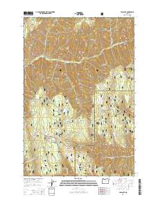
2014 Map of Tollgate
USGS Topo · Published 2014About this map
Tollgate serves as the central hub of this mountain survey, located near the southern edge of the Umatilla National Forest. The landscape is dominated by high ridges and deep canyons, with the South Fork Walla Walla River carving through the northern sections while Lookingglass Cr drains the south. Near the settlement, Langdon Lake provides a localized water feature amid a vast network of forest development roads that crisscross the terrain. The topography reveals a history of resource access and wilderness management, evidenced by the numerous named springs like Wild Woman Spring and Whisky Spring. Notable landmarks such as Blalock Mountain and Target Meadows define the high-elevation flats and peaks, while the boundary between Umatilla Co and Union Co bisects the eastern half of the sheet.
Find a feature on this map
62 named features on this map. Tap any name to fly to it.
Don’t see what you’re looking for? This feature index may not catch every label — zoom into the map to look around manually.
Map Details
Editions of this 2014 Tollgate Map
This is the sole edition of this map. No revisions or reprints were ever made.
Other maps of this area

1953 · Pendleton
USGS Topo · 1:250,000

1955 · Grangeville
USGS Topo · 1:250,000

1956 · Pendleton
USGS Topo · 1:250,000

1959 · Grangeville
USGS Topo · 1:250,000

1963 · Big Meadows
USGS Topo · 1:24,000

1963 · Andies Prairie
USGS Topo · 1:24,000

1963 · Bingham Springs
USGS Topo · 1:24,000

1963 · Tollgate
USGS Topo · 1:24,000

1963 · Blalock Mountain
USGS Topo · 1:24,000

1963 · Peterson Ridge
USGS Topo · 1:24,000