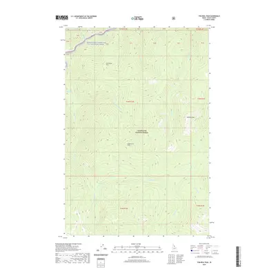
2020 Map of Tom Beal Peak
USGS Topo · Published 2020About this map
Jerry Johnson Hot Springs and the northern flow of the Lochsa River define the northern edge of this high-elevation wilderness. This portion of the Clearwater National Forest is characterized by extreme relief, moving from the river valley floor up toward prominent summits such as Tom Beal Peak and Hot Springs Point. The drainage network is complex, with Warm Springs Cr and Wind Lakes Cr cutting deep basins between high ridgelines like Cooperation Point. As part of the Middle Fork Clearwater Wild and Scenic River system, the landscape shows very little human development outside of basic forest infrastructure, preserving the natural hydrological patterns of Saturday Cr and other mountain tributaries in this remote Idaho County territory.
Find a feature on this map
30 named features on this map. Tap any name to fly to it.
Don’t see what you’re looking for? This feature index may not catch every label — zoom into the map to look around manually.
Map Details
Editions of this 2020 Tom Beal Peak Map
This is the sole edition of this map. No revisions or reprints were ever made.
Other maps of this area

1911 · Lolo
USGS Topo · 1:250,000

1913 · Lolo
USGS Topo · 1:250,000

1956 · Hamilton
USGS Topo · 1:250,000

1959 · Hamilton
USGS Topo · 1:250,000

1960 · Hamilton
USGS Topo · 1:250,000

1964 · Hamilton
USGS Topo · 1:250,000

1964 · Rocky Point
USGS Topo · 1:24,000

1966 · Mc Connell Mtn
USGS Topo · 1:24,000

1966 · Grave Peak
USGS Topo · 1:24,000
1966 · Hungry Rock
USGS Topo · 1:24,000