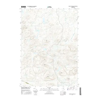
2016 Map of Tomany Mountain
USGS Topo · Published 2016About this map
The West Branch Sacandaga River defines the southeastern drainage of this high-country landscape, where the Hamilton Co / Fulton Co line crosses a region dominated by glacial lakes and sharp peaks. The terrain is characterized by a dense network of water bodies, including the large Sand Lake in the north and the cluster of Jockeybush Lake and Ferris Lake to the west. Peaks like Tomany Mtn and Ely Mtn rise above the interconnected wetlands of N Vly and Hard Vly Lake. Transportation is limited to a few corridors such as Powley Rd and Shaker Rd, reflecting a landscape preserved for its natural hydrology rather than industrial or residential development. This 2016 survey captures the intricate system of outlets and brooks, such as Sand-Lake Outlet and Shanty Brook, that feed the larger river system during the early twenty-first century.
Find a feature on this map
44 named features on this map. Tap any name to fly to it.
Don’t see what you’re looking for? This feature index may not catch every label — zoom into the map to look around manually.
Map Details
Editions of this 2016 Tomany Mountain Map
This is the sole edition of this map. No revisions or reprints were ever made.
Other maps of this area

1901 · Lassellsville
USGS Topo · 1:62,500

1903 · Gloversville
USGS Topo · 1:62,500

1903 · Lassellsville
USGS Topo · 1:62,500

1904 · Piseco Lake
USGS Topo · 1:62,500

1906 · Piseco Lake
USGS Topo · 1:62,500

1907 · Lake Pleasant
USGS Topo · 1:62,500

1908 · Piseco Lake
USGS Topo · 1:62,500

1943 · Gloversville
USGS Topo · 1:62,500
1945 · Stratford
USGS Topo · 1:24,000

1945 · Caroga Lake
USGS Topo · 1:24,000