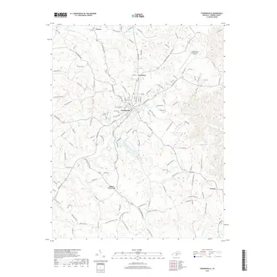
2019 Map of Tompkinsville
USGS Topo · Published 2019About this map
Tompkinsville serves as the central hub of this Monroe County landscape, situated amidst a dense network of ridges and winding waterways. The topography is defined by the circuitous path of the E Fork Barren River to the north and the numerous drainage systems like Mill Creek and Sulphur Cr that carve through the local terrain. Small outlying settlements such as Forkton, Grandview, and Hestand are connected by a web of rural routes, including Sulphur Lick Rd and Meshack Rd. For those researching local heritage, the map identifies significant family landmarks and resting places like Oak Hill Cem, Brown Cem, and Hammer Cem. Modern infrastructure is represented by the Tompkinsville-Monroe County Airport, while the community layout of Harlan Crossroads illustrates the traditional junction-based settlement pattern common in southern Kentucky.
Find a feature on this map
136 named features on this map. Tap any name to fly to it.
Don’t see what you’re looking for? This feature index may not catch every label — zoom into the map to look around manually.
Map Details
Editions of this 2019 Tompkinsville Map
This is the sole edition of this map. No revisions or reprints were ever made.
Other maps of this area

1929 · Tompkinsville
USGS Topo · 1:62,500

1931 · Red Boiling Springs
USGS Topo · 1:62,500

1953 · Sulphur Lick
USGS Topo · 1:24,000

1953 · Freedom
USGS Topo · 1:24,000

1953 · Dubre
USGS Topo · 1:24,000

1954 · Gamaliel
USGS Topo · 1:24,000

1954 · Tompkinsville
USGS Topo · 1:24,000
1954 · Vernon
USGS Topo · 1:24,000

1956 · Corbin
USGS Topo · 1:250,000

1958 · Corbin
USGS Topo · 1:250,000