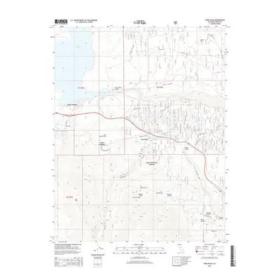
2015 Map of Toms Place
USGS Topo · Published 2015About this map
Toms Place serves as a central point in this high-altitude landscape where the Sierra Nevada meets the volcanic tableland of the eastern Owens Valley. The geography is defined by the sharp descent of the Owens River into the Owens River Gorge, a canyon formed through the Bishop Tuff Cutoff and other complex geological layers. This 2015 survey illustrates the modern layout of residential enclaves such as Aspen Springs and the recreation-oriented settlements near Lake Crowley, including South Landing. Transportation patterns are dictated by the terrain, with routes like the Old Sherwin Grade and the Casa Diablo Cutoff navigating the elevation changes around Sherwin Summit. From the meadows of Inyo National Forest to the specialized cattle and horse operations at Sky Meadow Ranch, the map reveals how human presence is carefully integrated into the drainage basins of Rock Creek and Birch Creek.
Find a feature on this map
44 named features on this map. Tap any name to fly to it.
Don’t see what you’re looking for? This feature index may not catch every label — zoom into the map to look around manually.
Map Details
Editions of this 2015 Toms Place Map
This is the sole edition of this map. No revisions or reprints were ever made.
Other maps of this area

1912 · Mt. Goddard
USGS Topo · 1:125,000

1914 · Mt. Morrison
USGS Topo · 1:125,000

1947 · Mariposa
USGS Topo · 1:250,000

1948 · Mariposa
USGS Topo · 1:250,000

1949 · Mt. Tom
USGS Topo · 1:62,500

1951 · Mt. Tom
USGS Topo · 1:62,500

1953 · Mt. Morrison
USGS Topo · 1:62,500

1953 · Casa Diablo Mtn
USGS Topo · 1:62,500

1953 · Mt Abbot
USGS Topo · 1:62,500
1954 · Mt. Tom
USGS Topo · 1:62,500