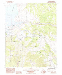
1984 Map of Toms Place
USGS Topo · Published 1984About this map
Lake Crowley and the surrounding high-altitude terrain of the eastern Sierra Nevada dominate this 1984 survey. The map details the complex water management and recreation landscape at the edge of Long Valley, where the Long Valley Dam regulates the reservoir and the Owens River enters the dramatic Owens River Gorge. Small settlements and seasonal outposts like Toms Place, Aspen Springs, and South Landing are positioned along the transit corridors and creek drainages that serve as gateways to the wilderness.
Find a feature on this map
40 named features on this map. Tap any name to fly to it.
Don’t see what you’re looking for? This feature index may not catch every label — zoom into the map to look around manually.
Map Details
Editions of this 1984 Toms Place Map
This is the sole edition of this map. No revisions or reprints were ever made.
Other maps of this area

1912 · Mt. Goddard
USGS Topo · 1:125,000

1914 · Mt. Morrison
USGS Topo · 1:125,000

1947 · Mariposa
USGS Topo · 1:250,000

1948 · Mariposa
USGS Topo · 1:250,000

1949 · Mt. Tom
USGS Topo · 1:62,500

1951 · Mt. Tom
USGS Topo · 1:62,500

1953 · Mt. Morrison
USGS Topo · 1:62,500

1953 · Casa Diablo Mtn
USGS Topo · 1:62,500

1953 · Mt Abbot
USGS Topo · 1:62,500
1954 · Mt. Tom
USGS Topo · 1:62,500