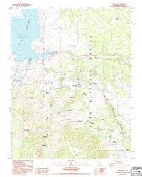
1990 Map of Toms Place
USGS Topo · Published 1990About this map
Crowley Lake dominates the northwest corner of this Eastern Sierra landscape, where the waters of the Long Valley are held back by the Long Valley Dam. The terrain is defined by sharp transitions from the canyon floor to the heights of the John Muir Wilderness and the Wheeler Crest. The small settlement at Toms Place serves as a gateway to the high country, positioned near the confluence where Rock Creek flows toward the Owens River Gorge.
Find a feature on this map
47 named features on this map. Tap any name to fly to it.
Don’t see what you’re looking for? This feature index may not catch every label — zoom into the map to look around manually.
Map Details
Editions of this 1990 Toms Place Map
This is the sole edition of this map. No revisions or reprints were ever made.
Other maps of this area

1912 · Mt. Goddard
USGS Topo · 1:125,000

1914 · Mt. Morrison
USGS Topo · 1:125,000

1947 · Mariposa
USGS Topo · 1:250,000

1948 · Mariposa
USGS Topo · 1:250,000

1949 · Mt. Tom
USGS Topo · 1:62,500

1951 · Mt. Tom
USGS Topo · 1:62,500

1953 · Mt. Morrison
USGS Topo · 1:62,500

1953 · Casa Diablo Mtn
USGS Topo · 1:62,500

1953 · Mt Abbot
USGS Topo · 1:62,500
1954 · Mt. Tom
USGS Topo · 1:62,500