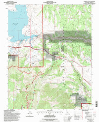
1994 Map of Toms Place
USGS Topo · Published 1997About this map
Toms Place serves as a central hub on this mid-1990s survey, situated where the high desert terrain meets the eastern slopes of the Sierra Nevada. The landscape is defined by the massive reach of Crowley Lake and the engineering of the Aqueduct, which draws from the Owens River Gorge below the Long Valley Dam. To the south and west, the terrain rises sharply toward the Wheeler Crest and the protected lands of the John Muir Wilderness, where peaks like Red Mountain tower over the drainage basins of Whisky Creek and Birch Creek. The map documents a mix of recreational and residential enclaves, from the lakeside docks at South Landing to the secluded Sky Meadow Ranch and Swall Meadow. Extensive networks of 4WD tracks and trails crisscross the Inyo National Forest, illustrating the transition from the developed corridor of the highway to the high-elevation meadows and peaks of the back country.
Find a feature on this map
40 named features on this map. Tap any name to fly to it.
Don’t see what you’re looking for? This feature index may not catch every label — zoom into the map to look around manually.
Map Details
Editions of this 1994 Toms Place Map
This is the sole edition of this map. No revisions or reprints were ever made.
Other maps of this area

1912 · Mt. Goddard
USGS Topo · 1:125,000

1914 · Mt. Morrison
USGS Topo · 1:125,000

1947 · Mariposa
USGS Topo · 1:250,000

1948 · Mariposa
USGS Topo · 1:250,000

1949 · Mt. Tom
USGS Topo · 1:62,500

1951 · Mt. Tom
USGS Topo · 1:62,500

1953 · Mt. Morrison
USGS Topo · 1:62,500

1953 · Casa Diablo Mtn
USGS Topo · 1:62,500

1953 · Mt Abbot
USGS Topo · 1:62,500
1954 · Mt. Tom
USGS Topo · 1:62,500