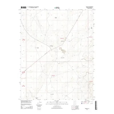
2014 Map of Tonalea
USGS Topo · Published 2014About this map
Tonalea serves as a central hub in this high-desert landscape, situated where Bia-21 meets the path of Us-160. The region is defined by a series of significant drainages and geological landmarks, most notably the distinctive Elephant Feet rock formation near the northern end of Red Lake. The mapping details an arid environment characterized by extensive valley floors and seasonal watercourses such as Porcupine Wash, Narrow Wash, and Begashibito Wash.
Find a feature on this map
22 named features on this map. Tap any name to fly to it.
Don’t see what you’re looking for? This feature index may not catch every label — zoom into the map to look around manually.
Map Details
Editions of this 2014 Tonalea Map
This is the sole edition of this map. No revisions or reprints were ever made.
Other maps of this area

1883 · Marsh Pass
USGS Topo · 1:250,000

1886 · Echo Cliffs
USGS Topo · 1:250,000

1891 · Echo Cliffs
USGS Topo · 1:250,000

1892 · Marsh Pass
USGS Topo · 1:250,000

1956 · Marble Canyon
USGS Topo · 1:250,000

1959 · Marble Canyon
USGS Topo · 1:250,000

1961 · Marble Canyon
USGS Topo · 1:250,000
1967 · Pillars of Hercules
USGS Topo · 1:24,000
1967 · Begashibito Canyon
USGS Topo · 1:24,000
1969 · Tuba City NE
USGS Topo · 1:24,000