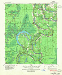
1941 Map of Tooleys
USGS Topo · Published 1954About this map
Black River meanders through the heart of Catahoula Parish, defining a landscape of landings and levees in this 1941 survey. The river's winding course is dotted with family-named transport points such as Beard Ldg, Smithland Ldg, and Lismore Ldg, illustrating a period when river traffic was essential to local commerce and travel. The surrounding terrain is a complex network of bayous and brakes, including Hudson Brake and Honey Brake, which frame the agricultural and residential pockets of Serena, Mayna, and Eva.
Find a feature on this map
111 named features on this map. Tap any name to fly to it.
Don’t see what you’re looking for? This feature index may not catch every label — zoom into the map to look around manually.
Map Details
Editions of this 1941 Tooleys Map
2 editions found
Other maps of this area

1935 · Tooleys
USGS Topo · 1:62,500

1939 · Red Gum
USGS Topo · 1:62,500

1939 · Artonish
USGS Topo · 1:62,500

1939 · Deer Park
USGS Topo · 1:62,500

1940 · Marksville
USGS Topo · 1:62,500

1941 · Manifest
USGS Topo · 1:62,500

1941 · Jena
USGS Topo · 1:62,500

1941 · Voorhies
USGS Topo · 1:62,500

1941 · Buckeye
USGS Topo · 1:62,500

1941 · Tooleys
USGS Topo · 1:62,500