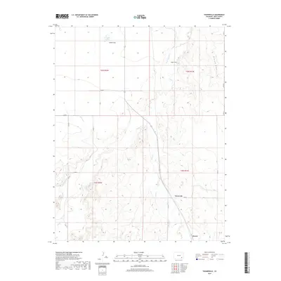
2019 Map of Toonerville
USGS Topo · Published 2019About this map
Toonerville and Ruxton anchor this portion of Bent County, where the high plains landscape is defined by the ephemeral flow of Rule Cr and Muddy Cr. The map reveals a reliance on water management in an arid climate, specifically through infrastructure like the Eagle Rock Ditch and the County Canal. These features, along with the Heinan Lake basin and the expansive Heinan Flats, indicate how the natural topography has been utilized for ranching or agricultural purposes. Surveyed landmarks such as Eagle Nest and Penrose Draw provide distinctive geographic points of reference across the township and range grid. The sparse network of roads, including Co RD 14 and Co RD K, connects these small hubs, reflecting the remote character of this southeastern Colorado region during the early twenty-first century.
Find a feature on this map
22 named features on this map. Tap any name to fly to it.
Don’t see what you’re looking for? This feature index may not catch every label — zoom into the map to look around manually.
Map Details
Editions of this 2019 Toonerville Map
This is the sole edition of this map. No revisions or reprints were ever made.
Other maps of this area

1891 · Higbee
USGS Topo · 1:125,000

1893 · Higbee
USGS Topo · 1:125,000

1955 · La Junta
USGS Topo · 1:250,000

1958 · La Junta
USGS Topo · 1:250,000

1966 · Toonerville SE
USGS Topo · 1:24,000
1966 · Gilpin
USGS Topo · 1:24,000
1966 · Toonerville
USGS Topo · 1:24,000
1966 · Toonerville NE
USGS Topo · 1:24,000
1966 · Hackamore Ranch
USGS Topo · 1:24,000
1966 · Turkey Canyon
USGS Topo · 1:24,000