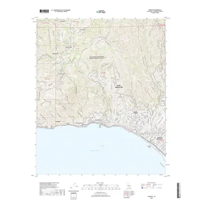
2018 Map of Topanga
USGS Topo · Published 2018About this map
The Santa Monica Mountains National Recreation Area dominates this coastal landscape, where the steep canyons of the Santa Monica Mountains meet the Pacific Ocean. This survey reveals the complex suburban-wildland interface of neighborhoods like Sylvia Park, Fernwood, and Pacific Palisades, where winding canyon roads and fire motorways navigate the ridgelines. The coastline is a series of named beaches and points, including Topanga Beach, Las Tunas Beach, and Big Rock Beach. Inland, the map captures the transition from the developed streets of Santa Monica and the Riviera to the protected open spaces of the mountains. Notable landmarks such as Parker Mesa and Inspiration Point overlook Santa Monica Bay, connected by a network of trails like the California Coastal Trail and the S Bay Bicycle Trl.
Find a feature on this map
159 named features on this map. Tap any name to fly to it.
Don’t see what you’re looking for? This feature index may not catch every label — zoom into the map to look around manually.
Map Details
Editions of this 2018 Topanga Map
This is the sole edition of this map. No revisions or reprints were ever made.
Other maps of this area

1894 · Los Angeles
USGS Topo · 1:62,500

1896 · Redondo
USGS Topo · 1:62,500

1896 · Santa Monica
USGS Topo · 1:62,500

1898 · Santa Monica
USGS Topo · 1:62,500

1900 · Los Angeles
USGS Topo · 1:62,500

1901 · Southern California Sheet No. 1
USGS Topo · 1:250,000

1902 · Santa Monica
USGS Topo · 1:62,500

1903 · Calabasas
USGS Topo · 1:62,500

1903 · Camulos
USGS Topo · 1:125,000

1904 · Southern California Sheet No. 1
USGS Topo · 1:250,000
Featured Places
- Los Angeles, CA
- Santa Monica, CA
- Malibu, CA
- Unincorporated Santa Monica Mountains, CA
- Sylvia Park, Topanga