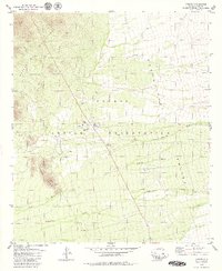
1979 Map of Topawa
USGS Topo · Published 1979About this map
Topawa serves as a central hub within the Papago Indian Reservation in the late 1970s, anchored by the San Solano Mission and the Indian Oasis Sch. The landscape is defined by the broad Baboquivari Valley, where the ephemeral drainage of Fresnal Wash, Topawa Wash, and Baboquivari Wash carve through the arid terrain. To the west, the Artesa Mountains and Topawa Hills provide significant relief, including the prominent Burro Mtn. Human infrastructure is sparse but critical, evidenced by the Landing Strip, several Cem locations, and the Topawa Well Water Tanks. This map captures a desert community structured around its spiritual and educational centers, with old Ruins and a Borrow Pit suggesting layers of land use and habitation in this Pima County expanse.
Find a feature on this map
19 named features on this map. Tap any name to fly to it.
Don’t see what you’re looking for? This feature index may not catch every label — zoom into the map to look around manually.
Map Details
Editions of this 1979 Topawa Map
This is the sole edition of this map. No revisions or reprints were ever made.
Other maps of this area

1941 · Presumido Peak
USGS Topo · 1:62,500

1941 · Baboquivari Peak
USGS Topo · 1:62,500

1941 · Vamori
USGS Topo · 1:62,500

1941 · Sells
USGS Topo · 1:62,500

1943 · Sells
USGS Topo · 1:62,500

1943 · Fresnal
USGS Topo · 1:125,000

1943 · Presumido Peak
USGS Topo · 1:62,500

1943 · Vamori
USGS Topo · 1:62,500

1944 · Baboquivari Peak
USGS Topo · 1:62,500

1956 · Nogales
USGS Topo · 1:250,000