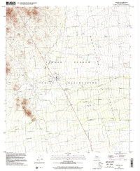
1996 Map of Topawa
USGS Topo · Published 2002About this map
The Tohono O'odham Indian Reservation dominates this desert landscape, centering on the settlement of Topawa. This community serves as a focal point for the region, housing the San Solano Mission and the Indian Oasis Sch. The topography is defined by the Artesa Mountains and the heights of Burro Mtn, which overlook the broad drainage of the Baboquivari Valley. A network of ephemeral waterways, including Fresnal Wash, Baboquivari Wash, and Topawa Wash, indicates the seasonal hydrological patterns of the Sonoran Desert. Infrastructure in this arid environment is highlighted by essential water sources like Topawa Well, along with various Water Tanks and a Well scattered across the valley floor. The map also records localized land use, such as a Borrow Pit and a Cem, providing evidence of community development and resources during the mid-to-late 1990s.
Find a feature on this map
15 named features on this map. Tap any name to fly to it.
Don’t see what you’re looking for? This feature index may not catch every label — zoom into the map to look around manually.
Map Details
Editions of this 1996 Topawa Map
This is the sole edition of this map. No revisions or reprints were ever made.
Other maps of this area

1941 · Presumido Peak
USGS Topo · 1:62,500

1941 · Baboquivari Peak
USGS Topo · 1:62,500

1941 · Vamori
USGS Topo · 1:62,500

1941 · Sells
USGS Topo · 1:62,500

1943 · Sells
USGS Topo · 1:62,500

1943 · Fresnal
USGS Topo · 1:125,000

1943 · Presumido Peak
USGS Topo · 1:62,500

1943 · Vamori
USGS Topo · 1:62,500

1944 · Baboquivari Peak
USGS Topo · 1:62,500

1956 · Nogales
USGS Topo · 1:250,000