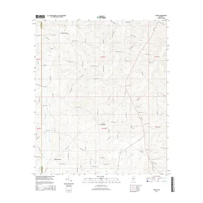
2015 Map of Topeka
USGS Topo · Published 2015About this map
Topeka and the surrounding rural landscape of Lawrence County are defined by a network of family-named roads and winding waterways. This 2015 survey illustrates a settlement pattern rooted in small commerce centers like Lamberts Store in the north and Bristers Store to the south. The terrain is intricately carved by several tributaries, most notably the meandering Halls Cr which bisects the quadrangle, and E Topisaw Cr tracing the western boundary. Numerous secondary roads, such as Carmel-New Hope Rd and Frog Ridge Rd, suggest a community deeply integrated with the land and local homesteads. Smaller water features like Coopers Cr and Tilton Cr further define the drainage of this Mississippi woodland area, providing essential context for understanding the local geography and historical property divisions.
Find a feature on this map
90 named features on this map. Tap any name to fly to it.
Don’t see what you’re looking for? This feature index may not catch every label — zoom into the map to look around manually.
Map Details
Editions of this 2015 Topeka Map
This is the sole edition of this map. No revisions or reprints were ever made.
Other maps of this area

1953 · Natchez
USGS Topo · 1:250,000

1956 · Natchez
USGS Topo · 1:250,000

1959 · Natchez
USGS Topo · 1:250,000

1970 · Topeka
USGS Topo · 1:24,000

1970 · Monticello
USGS Topo · 1:24,000

1970 · Darbun
USGS Topo · 1:24,000

1970 · Jayess
USGS Topo · 1:24,000

1970 · Nola
USGS Topo · 1:24,000
1970 · Tilton
USGS Topo · 1:24,000

1972 · Fair Oak Springs
USGS Topo · 1:24,000