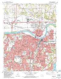
1983 Map of Topeka
USGS Topo · Published 1984About this map
The Kansas River bisects this mid-1980s landscape, serving as the historical divider between Topeka and North Topeka. The capital city’s institutional footprint is highly visible, anchored by the Capitol and extensive medical and educational complexes including the State Hospital, Washburn University, and the Winter VA Hospital. To the east, the neighborhood of Oakland sits near the Billard Municipal Airport, while the southern reaches show the developed suburban character of Highland Park and the leisure spaces around Lake Shawnee.
Find a feature on this map
64 named features on this map. Tap any name to fly to it.
Don’t see what you’re looking for? This feature index may not catch every label — zoom into the map to look around manually.
Map Details
Editions of this 1983 Topeka Map
This is the sole edition of this map. No revisions or reprints were ever made.
Other maps of this area

1889 · Burlingame
USGS Topo · 1:125,000

1889 · Topeka
USGS Topo · 1:125,000

1894 · Burlingame
USGS Topo · 1:125,000

1894 · Topeka
USGS Topo · 1:125,000

1947 · Lawrence
USGS Topo · 1:250,000

1950 · Kansas City
USGS Topo · 1:250,000

1950 · Lawrence
USGS Topo · 1:250,000

1950 · Topeka
USGS Topo · 1:24,000

1950 · Grantville
USGS Topo · 1:24,000

1951 · Grantville
USGS Topo · 1:24,000