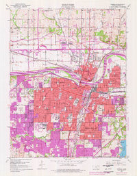
1950 Map of Topeka
USGS Topo · Published 1976About this map
The State Capitol anchors this detailed study of the Kansas capital city, showing the urban core as it appeared in 1950 with updates through the mid-1970s. The city's reliance on the Kansas River and a massive rail network is evident, with the Union Pacific, Atchison Topeka and Santa Fe, and Chicago Rock Island and Pacific lines converging near the water. Significant institutional grounds occupy large portions of the landscape, including Washburn University, the sprawling State Hospital, and the Winter VA Hospital. Beyond the central district, the map traces the residential growth of neighborhoods like Oakland and Highland Park, while the northern boundary is defined by Soldier Creek and the historic Old Indian Bdy. From the peak of Burnett Mound to the southern shores of Lake Shawnee, the sheet documents a city balancing its role as a political hub with its industrial and academic identity.
Find a feature on this map
79 named features on this map. Tap any name to fly to it.
Don’t see what you’re looking for? This feature index may not catch every label — zoom into the map to look around manually.
Map Details
Editions of this 1950 Topeka Map
Other maps of this area

1889 · Burlingame
USGS Topo · 1:125,000

1889 · Topeka
USGS Topo · 1:125,000

1894 · Burlingame
USGS Topo · 1:125,000

1894 · Topeka
USGS Topo · 1:125,000

1947 · Lawrence
USGS Topo · 1:250,000

1950 · Kansas City
USGS Topo · 1:250,000

1950 · Lawrence
USGS Topo · 1:250,000

1950 · Topeka
USGS Topo · 1:24,000

1950 · Grantville
USGS Topo · 1:24,000

1951 · Grantville
USGS Topo · 1:24,000